 Source: DMTI (2006), Geogratis (1966), ToL (1986, 2001)
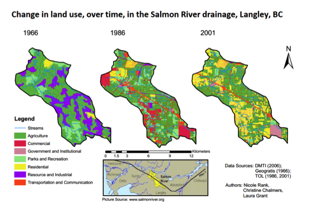
This map clearly shows the emphasis that the successive Township of Langley councils have given to commercial and residential development in the Salmon River watershed since 1966.
Marvin Rosenau, a BCIT fish and wildlife expert, presented a report to the council on Oct. 26, 2013 that included this map of land use changes.
Impervious covers such as roads, parking lots, buildings with large roofs, lawns and even large greenhouse complexes negatively affect fish communities. “Habitats start to unravel,” he said. “The science is pretty straightforward.”
The Hopington aquifer, essential for providing drinking water in Langley and maintaining streams, is threatened and water levels are dropping.
He advised the council to direct township staff to hire independent groundwater experts before approving development near the river.
In addition, council has been turning to the sale of township property to pay for infrastructure and recent decisions have gotten council members into hot water. The McLellan Park Blog has some comments about the process: “…past and present policy with regard to the sale of what the Township has identified as ‘surplus property’ has generated much controversy. The approach that the Township has taken appears to many to be secretive and reactive. There is an obvious need for a process with greater transparency, one grounded in sound planning.”
UBC’s Land Use Analysis of the Salmon River Watershed
Other issues
Farming impacts on Langley rivers
Water pipe causes environmental damage
Uncapped artesian wells draining aquifer
Water Sustainability Act
Kinder Morgan Pipeline
Development pressures
Rain/impervious surfaces
Flooding
Damn beavers!
Endangered species
Invasive species